
Today Bishops’ House is located between the suburbs of Meersbrook and Norton Lees. Now in Sheffield, these places were once part of the Derbyshire countryside. Meersbrook refers to the boundary line marked by the Mears Brook (‘meer’ being old English for boundary). This was the boundary between the kingdoms of Mercia and Northumbria, later becoming the boundary between Derbyshire and Yorkshire.
Before Victorian times Meersbrook was an area of fields leading down to the Meers Brooke rather than a settlement as such. When Bishops’ House was built people would have said the building was in Norton Lees. Norton Lees means ‘forest clearing in Norton’, with ‘Ley’ (also spelled ‘lee’ or ‘lea’) being old english for a forest clearing and ‘Norton’ meaning ‘northern settlement’. A number of Sheffield’s suburbs are similarly named, such as Heeley, Totley, Tinsley, Wadsley and Walkley.
Today Norton Lees is a suburb of similar size to the neighbouring village of Norton, but the place was little more than a cluster of buildings when Bishops’ House was built. Norton, Norton Lees and Meersbrook were all once part of the much larger area of Norton Parish, which also contained Heeley, Little London, Smithy Wood and Woodseats, as well as Bradway, Greenhill, Jordanthorpe and Hemsworth. Norton Parish became the principal area in the north of England for making sickles and scythes in the sixteenth century, and the tradition continued well into Victorian times.
Hover over the maps below to move the slider and compare the area in about 1800 with today’s map. (This rewards looking at on a larger device.. on a mobile device try tilting to landscape mode and pinch to zoom)


Below is a sequence of maps, with explanations below, showing how much the area has changed. Click the arrows to cycle through.


The text accompanying the maps that you can scroll through above is by Ken Dash and was taken from a larger document which is reproduced below. As mentioned elsewhere on this site, Ken has painstakingly researched all matters Bishops’ House and, not satisfied with that, he has more lately been researching the wider area too.
Below are two overlapping articles by Ken, beginning with Meersbrook and Norton Lees, which considers how the area has developed in a number of ways, but also includes a tour of places of interest. Following on from that is, The Village of Norton Lees, which focusses more closely on some of the well known – and for the most part now sadly lost – buildings that were in the vicinity of Bishops’ House.
INTRODUCTION
This website is mainly about Bishops’ House but we thought that we ought to set the House in its background of a small Derbyshire village and the changes that happened over the centuries. This is not an attempt at writing about Sheffield’s history. There are several good books about the subject. This is just a brief overview of the local area and its history
It is a small glimpse into a vanished world.
THE CHANGING LANDSCAPE
Almost a thousand years ago, at the time of the Domesday survey of 1086, our area was very different from the modern landscape. Looking at the area that was woodland at the time has shown that the West Riding of Yorkshire was 16% woodland. A similar figure for South Yorkshire, just under 13% has been calculated. I had a go at looking at how much of North Derbyshire was wooded in 1086. Fortunately, the Domesday survey is now online and I was able to sum up all the woodland of the many villages. The results were quite a surprise. My figures show that in contrast to the low-lying land of West and south Yorkshire, not much of the hilly upland of North Derbyshire had yet been cleared for farming with 65% woodland, only 17% meadow and arable land and 18% heath and moorland. The type of woodland had a boundary at about the position of Sheffield and North Derbyshire, with forests of Oak and Hazel dominating to the north and Lime to the south.
Almost five hundred years later, Bishops House was built in 1554, in the short but turbulent reign of Mary Tudor (1553 to 1558) and is the last surviving building from that era in the tiny village of Norton Lees in the parish of Norton. The name ‘Norton Lees’ simply means the northern clearing. Many of Sheffield’s suburbs have names ending in ‘ley’ or ‘lee’ (Heeley, Totley, Tinsley, Wadsley, Walkley etc.). a ‘ley,’ ‘lee’ or ‘lea’ simply means a forest clearing. For the first four hundred years of its existence, Bishops’ House lay in a rural landscape where little changed for centuries. Old maps of Woodseats, Heeley and Norton from the 1720s to the 1740s show a completely rural area with the land divided into fields for agriculture and only the beginnings of any villages. The Parish of Norton was bordered by Heeley and the Meers Brook in the north, down through Little London, Smithy Wood, Woodseats and Beauchief and Dore and Totley, all bordering the Sheaf, then turning east to Bradway, Greenhill, Norton and Hemsworth. Norton parish was the principal area in the north of England for making sickles and scythes in the sixteenth century, and the tradition continued well into Victorian times. There were several local farms – Arbourthorne Farm, Ash Farm, Paddock Farm, Carrfield Farm, Cockshutts Farm, Bole Hill Farm, Cowmouth Farm, Backmoor Farm, Hemsworth Farm, Grange Farm, Lees Hall Farm and Cockshutts Farm. Many of the old farm buildings survived into the 20th century when they were demolished for modern housing estates. A few of the local farms are described below. A map of Heeley from 1796 shows that it was no more than a group of extended farms, divided into Heeley, Upper Heeley and Heeley Green. Norton Lees was a small community around Bishops House. There was more occupation where modern Gleadless lies and the beginnings of Woodseats. There were several water-driven mills along the Sheaf – Bartin Wheel, Ecclesall Mill, Moscar Wheel, Norton Hammer Wheel, Smithy Wood Wheel, Little London Wheel, Heeley Corn Mill, Heeley Wheel, Heeley Tilt and, along the Meers Brook, Blyth Mill. Many of these began their working lives in the 16th or 17th centuries.
By the middle of the nineteenth century little had changed. A few field boundaries had moved and a few farm tracks became minor roads. The Parish Church of Christ Church, Heeley was built from November 1846 and consecrated in August 1848. The primitive Methodist Chapel was built in 1858 on what was then called Sheaf Street and is now Gleadless Road. This building was the original meeting place for the Primitive Methodists. But the pace of life was beginning to change. Work started on the Midland Railway to connect Sheffield to the south of England in 1864. The railway line was driven through the Sheaf Valley, obliterating many of the local water mills and opened in February 1870 along with the local Heeley Station. The first of the modern roads were laid out in Heeley by 1872 including Myrtle and Alexandra roads. By the end of the nineteenth century the area began to be built on. The modern streets of Heeley had been laid out and road building was beginning to enclose the area of Meersbrook Park. The area that we now call Meersbrook only began as a suburb at the end of the nineteenth century when the first streets were laid out. But most of the area was still rural and many of the fields that had been in use for hundreds of years were still farmed. The border between Sheffield and North Derbyshire, which used to lie at the Meers brook, was moved south in 1903 following the Sheffield Corporation Act. Meersbrook, Meersbrook Bank, Norton Lees, Norton Hammer, Blackmoor, Little Norton and Norton Woodseats were added to the City of Sheffield.
By the 1920s much of what we regard as Heeley, Norton, Meersbrook and Woodseats had been laid out as streets. Very little of the old rural landscape remained. In 1930 the three cottages next to Bishops’ House were demolished. Two big houses close to Bishops’ House, The Hollies and Thorpe House, were demolished by the early 1930s to make way for the Hollythorpe estate, built in 1934. During the Second World War Sheffield was bombed in December 1940, hundreds of bombs landing in our area. Many local people were homeless and Anns Road Church in Heeley helped to give temporary shelter. With the building boom of the post war years more streets were laid out. But change wasn’t always one-way. The last electric tram ran in October 1960. The Meersbrook was culverted in 1957. Heeley Railway Station closed in June 1968 following the Beeching cuts to the railway system. By the beginning of the twenty first century few places remained unfilled by streets and houses. In 1974 the occupants of Bishops’ House moved out and the building was restored, opening as a museum in 1976. In 1977 four streets in Heeley were demolished to make way for the Heeley Bypass. As we know this was never built and instead Heeley City Farm has occupied the land since 1981. In 1988 Sainsbury’s Homebase was built on the old quarry site on Chesterfield Road. The old Heeley railway sidings, once occupied by Greshams Timber Yard, was built over as Heeley Retail Park.
POPULATION
For the earliest times, I have looked at Derbyshire, as Sheffield didn’t exist at the time, and Norton was, until the boundary changes of 1903, in North Derbyshire. The Domesday survey records only three households in Norton. I would guess that the total population for the Scarsdale hundred, which occupies about the same area as North Derbyshire, would be two or three thousand.
The population of the whole of Derbyshire, assessed in the year 1377 for the poll tax, was 24,289. The population of Derbyshire in 1789 was 124,465; in 1801, 161,142 and in 1811; 185,487. For comparison, Derbyshire’s population in 2022 was 1,067,000.
The earliest reference to Sheffield’s population that I have been able to find dates from 1571 when it was estimated at only 833 in the township with a total of 1,676 in the parish. By 1672 the township’s population had risen to 2,311 with 4,685 in the parish.
By 1700 Sheffield was still little more than the largest of a group of villages clustering in the valleys of South Yorkshire and North Derbyshire. The survey of 1736 puts the population of the town at about 10,000. By 1750 it may have exceeded 12,000 while that of the parish as a whole has been estimated at 20,000.
At the end of the eighteenth century England was a country of about eight and a half million people, at war with Napoleon Bonaparte, and George III was on the throne. Sheffield at the time was still a small town, probably no more than 1,500 m across and with only 46,000 in the Parish of whom nearly 31,500 lived in Sheffield Township and about 35,000 living in the urban, built up area. But the Industrial Revolution had begun with the invention of Crucible Steel and Sheffield Plate. The population slowly increased to 111,000 by 1841, after which there was a much sharper increase to 185,000 by 1861. The next village in towards Sheffield from Norton Lees, Heeley, had a similar slow increase in population until the middle of the 19th century, after which there was a dramatic rise.
Norton Lees, by contrast, was always a small isolated rural community whose population remained broadly static at around 100, not reflecting the massive changes from the rural landscape of centuries, to increasing urbanisation. Divided by fields and a few areas of woodland it was finally absorbed into Sheffield as late as the 1930s.
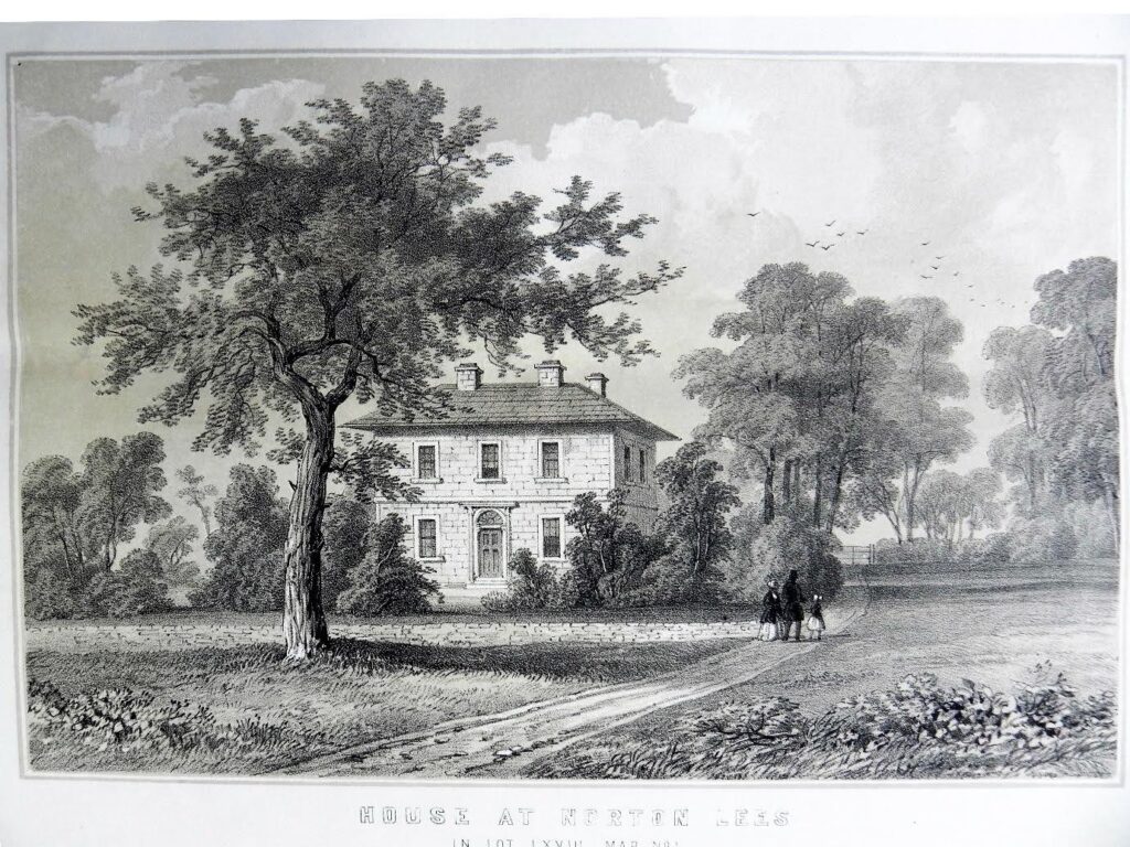
Apart from Bishops’ House, few other early buildings survive. The grandest house in the local area was Norton Hall, built in 1815 by Samuel Shore, and Meersbrook Hall, built in 1759 for local businessman Benjamin Roebuck.
THE MEERS BROOK
The Meers Brook (older spelling Mears Brook) is a tributary of the river Sheaf. It originates as a spring in the Gleadless area and runs for some 3,400 m west until it flows into the Sheaf near Saxon Road and Clyde Road. The name means ‘boundary brook’ and at one time it formed the boundary, along with the Sheaf, between the Anglo-Saxon kingdoms of Northumbria, to its north, and Mercia, to its south. It remained as the border between Yorkshire and Derbyshire until 1901. From 1957 the part of the Meersbrook which had run as an open stream behind the back gardens of Albert Road to the north and Valley Road and Rushdale Road to the south was covered over but if you walk along its route with a good map, you can still see, here and there, traces of its course.
TRANSPORT
The Midland Railway and Heeley station
The site of Heeley Railway Station lies on Chesterfield Road. The station itself was built on the bridge over the road, close to the junction with Gleadless Road. Construction of the Midland railway into Sheffield began in 1864 following parliamentary approval. Over a thousand recently built houses on the approach to Sheffield were compulsorily purchased and then demolished. By August 1867 work on the Bradway Tunnel was progressing. Stations were built at Dronfield, Abbey Houses, Ecclesall and Heeley. The railway opened in February 1870. Heeley Station originally had two platforms. It was widened with four platforms replacing the original two between July and September 1902. The station stayed open for another six decades, finally closing in June 1968 following the Beeching cuts to the railway system. Today all that can be seen from Chesterfield Road is a weed-choked and blocked entrance just south of Heeley Bridge.
Albert Road Tram Depot
This building is situated on Albert Road about 50 m from the junction with Chesterfield Road. It is a Grade II listed building which has now been converted to flats. The original entrance is on Albert Road and above the stone and brick arch the words ‘Sheffield 1878 Tramway Company’ is carved into stone. The first horse-drawn trams ran from Lady’s Bridge to Attercliffe in 1873. The line from Moorhead to Nether Edge and Heeley opened in 1877. Tram sheds in Albert Road were opened in 1878. During the conversion to flats in 2006 the archway was demolished and rebuilt at a slightly higher level than when first built. The last of the horse-drawn tramcars ran in 1902 and the last electric tram ran in October 1960.
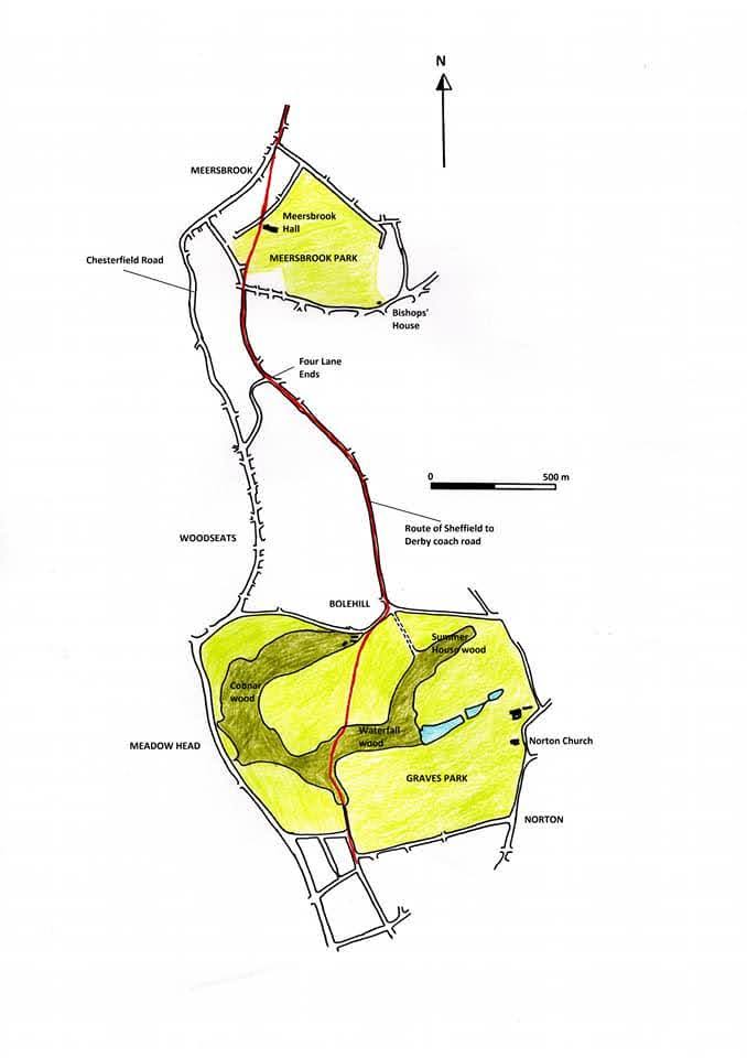
The old coach road
The main route out of Sheffield, and the only major road in the area was the Sheffield to Derby Road which ran from the town up through Heeley and through where Graves Park now lies. This road has been traced back on old maps to 1724, 1737 and 1741 when it was no more than a horse and cart track. It probably existed in this form for a long time before, as there is a reference to a bridge at Heeley in 1650. We also have a tax return for Captain William Blythe of Bishops’ House, dated 1656 which mentions ‘the house and croft at the four lane ends,’ the crossroads between Derbyshire Lane and Scarsdale Road. This shows that the old road, now Derbyshire Lane, existed then. An earlier reference mentions that William Hobson and Katherine, former surname Samford, had a son, George Hobson, of Four Lane Ends, who was baptised on the 26th of December 1616.
It was properly widened and metalled in 1756 and made into a toll road. The toll bar was in Heeley, about where the Red Lion pub is now. From there the road ran straight up the hill, close to the entrance to Meersbrook Hall, which had been built in 1759, past the Walled Garden and then on up the current Derbyshire Lane. It was too steep for most passenger coaches and an extra horse was added to pull the coaches up the hill where the Park is now.
In 1797 the modern Chesterfield Road was laid down; built as a turnpike road from Sheffield to Chesterfield. An attempt was made to cut a new route for the coach road, joining Chesterfield Road to the upper part of Derbyshire Lane and bypassing the old route. This resulted in the modern Derbyshire Lane being laid out, but it was still a steep road. The old coach road fell into disuse after this time and there is no trace of it on the 1804/05 map, though for its forty-one-year life (1756 to 1797) it provided one of the main roads out of Sheffield.
A record from 1787 lists several regular passenger coaches using the road, going to Chesterfield, Derby, Burton, Lichfield, Birmingham, Nottingham, Leicester, Northampton and London.
Some travel times for early coaches:
1760 – Sheffield to London: 3½ days (i.e. about 84 hours).
1765 – Sheffield to Chesterfield: 3 hours.
1778 – Sheffield to Birmingham: 13 hours.
1785 – Sheffield to London: 31 hours.
Chesterfield Road
The main north – south road is the A61 London Road South/Chesterfield Road dating from 1797 when it was laid down as a turnpike road from Sheffield to Chesterfield. The turnpike method of financing and controlling the repair of old roads or the making of new ones, were applied in the district by no fewer than twenty two Acts of Parliament between 1739 and 1818 dealing with main routes. This road replaced the earlier Sheffield to Derby coach road which ran through Meersbrook Park, then up Derbyshire Lane and Graves Park. The first horse drawn tramway route was opened in 1873 and reached Nether Edge and Heeley by 1877. Tram sheds in Albert Road were opened in 1878. The first electric trams were introduced in 1899 and the last of the old horse drawn trams ran in 1902. Tram tracks were laid down on Chesterfield Road in 1903 and the trams ran until 1960.
Heeley Bridge
The plaque on the east side of the bridge says that the current bridge was built about 1869. There has been a river crossing at this same place, traceable maps from 1904 back to 1796. After 1756 the road south from Sheffield crossed the Sheaf some 50 to 60 m to the west of its current position and then continued south across the bottom of the current Gleadless Road. Before that the Sheaf crossing was about where Well Road meets London Road. Evidence for a river crossing at Heeley existing before 1650 comes from an edition of the Sheffield and Rotherham Independent dated Tues. 30/08/1864. On p 3 a correspondent quotes from the notes of his four times great grandfather Stephen Fox, who records repairs to the bridge between October and December 1650.
Only the 1845 map of Norton parish records the use of the land. From counting the fields and their area it has been possible to reconstruct how the land was divided. 38% of the land was arable and the trade directory for 1883 says ‘the chief crops are wheat, oats, barley, turnips and hay.’ 36% was grass and we can presume that it was used to graze cows for the dairy farms. The directory for 1862 says ‘and here many large dairies of milch cows.’ 7% was arable and grass. 11% was wooded, including some new plantations. 4% were parks and plantations of woodland; some of the areas that would one day become Meersbrook and Oaks parks. The remaining 4% is land occupied by and surrounding buildings, forges, dams etc. This was a last look at a world that was soon to vanish. By the 1870s, the very first streets of Heeley, Woodseats and Meersbrook were being laid out and a farming landscape stretching back for many centuries would be replaced by the suburban streets we walk on today.
Jos Kingston’s account of Norton says ‘In the sixteenth century, Norton had a clear identity of its own, as the principal scythemaking community in the north of England.’ This tradition carried on into the nineteenth century and the trade directories for 1833, 1841, 1849, 1852, 1856, 1864, 1868 and 1876 all say that the area is known for ‘scythes, sickles and reaping hooks, for which there are several forges and grinding wheels.’ The trade directory for 1862 mentions ‘scythes, sickles, files and cutlery.’ The trade directory for 1879 mentions ‘files, cutlery, scythes, sickles and reaping hooks.’ The introduction to the Norton Parish Registers quotes the ‘View of the Present State of Derbyshire’ (1779) which says that ‘there were 136 scythe makers and 25 grinders’ at Norton.
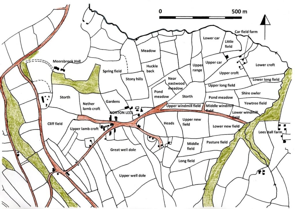
Fig 2 The area showing the main farms, about 1800.
Carfield Farm
The seventeenth century
The first mention of the farm is from 1664, with William and Maria Gillat living there with their two daughters, Maria (b 1664) and Anna (b 1669). Edward and Maria Newton had four children: Edward (b 1674), John (b 1678), Martha (b 1680) and Rachel (b 1686). Matthew and Elizabeth Staniforth had one daughter, Hannah, (b 1693). Matthew died in 1729 and Elizabeth in 1735.
The eighteenth century
Robert and Anne Staniforth had five children: Maria (1732-1741), Elizabeth (b 1735), Samuel (1739), Milicent (b 1744) and Sarah (d 1752). Robert’s wife Anne died in 1757. Hannah, daughter of Abraham and Hannah Bertles (b 1764). John and Sarah Bingham had a son, John (d 1767). Mary, wife of John Bingham senior (d 1768). John and Elizabeth Green had a daughter, Elizabeth (b 1779). George and Ann Shortland had two children: George (b 1782) and Ann (b 1785). William and Elizabeth Smedley had one daughter, Hannah (1781-1783). Matthew and Martha Oudall (also spelled Oldall and Oldale) had eighteen children: Matthew (1774-1779), Robert (1776-1779), Martha (1777-1779), Peter (b1779 d1779), Ann (d 1779), Joseph (b1780 d1780), Mary (b1780 d1780), Elizabeth (1781-1782), Thomas (b1781), Hannah (b1783 d1783), John (b1783 d1783), Godfrey (b1784), Luke (d 1786), William (1787), Samuel (d 1788), James (1789-1790), Another Samuel (b 1791) and Sarah (b1791). Of all these children, thirteen of them died young, seven in a ten month period between April 1779 and February 1780. Only sons Thomas, Godfrey, William, Samuel and daughter Sarah survived.
The nineteenth century
Thomas went on to manage the farm and is mentioned in the 1805 map of Norton Parish, farming 59 acres. He married a woman called Sarah and they had at least one child, a daughter Mary, born in 1805. The 1841 to 1861 censuses show Richard Booker (b 1788) farming between 59 and 64 acres at different times. He married Mary (b 1791) and they had three children: Richard (1814-1865), Mary (b 1821) and Ellen (b 1824). The 1851 census shows Joseph Binghm (b 1815) farming 12 acres with his wife Ann (b 1813). They had three daughters: Ann (b 1846), Mary (b 1848) and Sarah (b 1850). The 1861 census shows Mary Gillatt, a widow (b 1812) farming 25 acres with her two children: Thomas (b 1847) and Mary (b 1850). The 1871 census shows three families living at the farm: John Johnson (b 1833), a carpenter with his wife Mary (b 1836) and their seven children: William (b 1856), Martha (b 1858), Gertrude (b 1862), Ada (b 1863), Eva (b 1867), Minnie (b 1868) and Arthur (b 1870). Henry Ashton, an agricultural labourer (b 1831) with his wife Ann (b 1840) and their three children: Jonathon (b 1865), Henry (b 1866) and Ann (b 1869). John Barker, a retired bricklayer (b 1815) with his wife Elizabeth (b 1809) and their son William (b 1851). The 1881 census lists George Roberts, a pen machine maker (b 1835) living there with his wife Agnes (b 1838) and their eight children: John (b 1862), Morgan (b 1865), Sam (b 1867), Edith (b 1868), Frank (b 1870), Frederick (b 1873), Jessie (b 1877) and Alice (b 1880). John and Elizabeth Barker are also there.
Carfield – A note on the name
The term carr is an Old Norse woodland name that has survived as a general place name, as in Deepcar. When applied to woods it described low lying woods bordering streams and rivers in which alders and willows predominated. There is a Carr Wood between Heeley and Gleadless. It occupies the narrow valley of a tributary of the Meers Brook and was referred to as ‘Carr Wodd’ in 1583.
Fig 3 Carfield farm. Date unknown.
Cliff Field House
Cliff Field House was built before 1796. The first recorded tenant, from 1798, 1804-05 and 1817 was Martin Goddard. In 1841 and 1845 the tenant was listed as Robert Brownhill (b 1807), living there with his wife Elizabeth Brownhill (b 1818) and their children: William Brownhill (b1835), Robert Brownhill (b 1836) and Peter Brownhill (b 1837) and their servants. In 1850 it was described as ‘Mansion House comprising Dining, drawing and Breakfast Rooms, eight lodging Rooms, Kitchens, and Cellars; with Stables, carriage House, Pleasure Ground, Garden, Cottage House, and Outbuildings. The tenant is the late Mr R. Brownell.’ A succession of tenants followed. The 1861, 1871 and 1891 censuses listed John Ryalls, attorney at law and later a barrister (1805-1888) living there with his wife Ruth Ryalls (1804-1903) and their children: Louisa Ryalls (b 1833), Frances H Ryalls (1834-1916), Charles W Ryalls (b 1840), Leonard A Ryalls (1841-1915), Emilia Ryalls (1844-1893) and Charlotte A Ryalls (b 1847). Also there in 1861 were John Woodhead (b 1804), an agricultural labourer, his wife Mary Woodhead (b 1812) and their children: Mary Woodhead (b 1840) and Arthur Woodhead (b 1855). In 1871 John Tyzack (b 1803), a widowed gardener was living there with his daughter Mary Tyzack (b 1826). John Tyzack is also listed in the 1881 census. The 1871 census also lists two brothers, George Needham (b 1848) and William V Needham (b 1852). The 1891 census shows John Ryall’s son, Leonard Ryalls, a solicitor, living there with his four unmarried sisters, Elizabeth, Louisa, Frances and Charlotte, and Sarah Tyzack (b 1830) as their cook. The house appears on the 1894 map but had been demolished by 1898 when the first of the streets of the new suburb of Meersbrook were laid down.
Fig 4 Cliffefield House 1850.
Cockshutts Farm
Records of the farm are scanty with only a few people mentioned before the late eighteenth century.
The eighteenth century
Maria, wife of Thomas Chantry (d 1703). Thomas, son of Thomas & Sara Pashley (b 1717). Gamaliel Egbarrow (d 1723). Nancy, daughter of the widow of Robert Merill, farmer (b 1741). Elizabeth, daughter of Joseph and Elizabeth Hudson (b 1774). Amelia, daughter of Joseph & Millicent Ashberry (b 1779). John and Hannah Grey had two children: Sarah (b 1782) and John (b 1785). Elizabeth Tomlinson (d 1785). Ann, wife of William Stevenson (d 1789).
The nineteenth century
John and Elizabeth Bell had one son, John (b 1805). William and Elizabeth Mason had a daughter, Ann (b 1811). Mary, daughter of John and Mary Thompson (b 1815). The 1841 census lists Thomas Fretwell (b 1791), a farmer, living with his wife Elizabeth (b 1791), their daughter Ann (b 1816) and sons William (b 1821) and John (b 1826). The 1851 census lists Joseph Hudson (b 1786), a farmer of 20 acres, with his wife Mary (b 1788) and their son George (b 1827). The 1861 census lists William Wright (b 1811), a farmer of 26 acres, with his wife Mary (b 1816) and their children William (b 1848) and Mary (b 1851).
Their son George married Sarah Cadman (b 1817). They had one son, John (1848-1916). He married Sarah Revell (1852-1921).
The census returns between 1851 and 1891 show the Fawcett family farming at Cockshuts farm. The 1851 census also shows the Faircroft family farming there. George Faircroft (b 1777), farmer of 68 acres and his wife Elizabeth (b 1777) had one daughter, Sarah (b 1819).
Cockshutts – A note on the name
A Cockshutt is a broad way or glade in a wood through which woodcocks and other birds might dart or shoot, to be caught by nets stretched across the opening.
Fig 5 Cockshutts farm 1910
Cowmouth Farm
Early occupants – the 16th and 17th centuries
The first record of someone living at Cowmouth Farm is of John Rose, carpenter, and his children Elizabeth (b 1567) and John (b 1570). Leonard Trycket and Elizabeth Burnell had a son, John (b 1584). An infant daughter of Francis Bate, stryker, (d 1591). John Barnes, scythe-smith (d 1603).
The eighteenth century
There is then a long gap in the parish records until the Linley family in the late 18th century. Thomas and Mary Linley had three children: Mary (1793-1811), Sarah (b 1799, d 1799) and Thomas (b 1805).
The nineteenth century
The 1805 parish map shows Thomas Linley farming 102 acres at Cowmouth Farm. Mary, wife of Thomas Linley, was buried in 1811. Their son, Thomas, married Mary Allen in 1835. They had seven children: Mary Ann (b 1836), Thomas (b 1838), Peter (b 1839), William (b 1840), John (b 1843), Samuel (b 1845) and Mary (b 1848).
Due to the collapse of the Parker Shore bank Cowmouth Farm was put up for sale by the receivers in 1850. The farm was described as having a rental value of £170 and being 120 acres. A bid was put in for £4,000 by a Mr. Shortridge but the bid was deemed as insufficient and the farm was withdrawn. The Linleys moved to a farm in Eckington and Cowmouth was bought by the Rev Henry Barlow of Christchurch, Pitsmoor in 1853. In 1857 Elijah Wragg was the tenant there. From 1861 it became the tenancy first of Joseph Carr, then other members of the Carr family.
The census returns from 1861 to 1901 show Joseph Carr farming 43 acres. He and his wife Sarah had seven children; Frederick (b 1859-1921), Sarah (b 1862), George (b 1865), William (b 1868), Florence (b 1871), Hannah (b 1871), Lucy (b 1873) and Lily (b 1876). The Rev Barlow died in 1878 and an attempt was made to sell the farm to develop the land for housing. It is not known why this didn’t happen although some parts of the farm were sold off. The farm continued to remain in the Barlow family. In 1909 Henry Barlow’s great nephew sold three fields, and the top part of Warminster was developed for housing.
There was a local scandal when 22-year-old Frederick Fox Carr ran away with Clara Robinson of Bolehill Farm and they were married in Matlock. He came back to Sheffield to be a butcher with a shop on Chesterfield Road, but became a milkman and, on his death in 1921, two of his children – JW Carr and Doris M (Carr) Widdowson took over the milk round. The business was sold to Amos Knowles in 1959, who was then living at the farm and this became Express Dairies when Mr Knowles retired, and then the Association of Co-Operative Creameries and the Dairy Farmers of Britain until the site was sold and planning permission for a housing development was sought.
From the Norton Free admission books, there was a child Jenkinson at Cowmouth Farm in 1904 and a child Knowles in 1914. In a 1948 Directory, both Avery Knowles and Amos William Knowles are listed as milk dealer, Cowmouth Farm.
When the Carrs ran their dairy farm they had the following fields – The Spring field, The Footway field, The Long field, The Square Bent field, The Croft, The Ponds, The Garden field, The Turnpike field, and the farmhouse, yard and garden and a Plantation. It comprised 43 acres, 2 roods and 22 perches.
In July 1950 the Sheffield Astronomical Society had plans for an observatory at the farm and presented them to the Council. Eventually, the plans were passed and construction took place at a cost of £150. A deed for the lease of the land at Cowmouth Farm was signed and included the stipulation that the Society provide a fence to prevent the cattle getting too near the Observatory. In 1956 the Bramley fields from the farm were made into playing fields for Sheffield University.
Fig 6 Cowmouth farm 1986.
Lees Hall Farm
There is a long record of occupation at Lees Hall Farm from before 1607. There is some overlap between the families, which would indicate that at some times, more than one family was living there; perhaps not surprising for such a large building. Much of the early record of occupation is disjointed and reflects what is in the Norton Parish Records rather than a full account. Lees Hall was a massive building and we don’t know which of these families were farming and which were just occupying it until the account of John Lowe in the 1730s (see below). The Booker family took the farm’s occupation from the late eighteenth until well into the nineteenth century, after which the Butcher family took over. At various times the farm was recorded as being between 70 and 100 acres.
The seventeenth century
John Parker died in 1607, or 1615, leaving Lees Hall, mills and other property to his wife Mary. In 1626 Humphrey Cardinall, was at Lees Hall. His wife Maria was buried in 1627. Sellbee Massenn and Margaret Barker of Lees Hall had a son, also Sellbee in 1659. Thomas and Mary Roper had a son, Philip in 1660. Francis and Anna Barker had four children: Robert (b 1660), Francis (b 1664, d 1664), William (d 1667) and an infant son (d 1671). Anna was buried in 1671 and Francis in 1685. John and Anna Cave had two children: Elizabeth (1673) and Francis (b 1676, d 1676). Anna Cave was the daughter of Francis Barker. John Cave died in 1677 and Anna married John Bright (see below). Jana Rodgers, wife of John Rodgers was buried in 1677. John and Anna Bright (formerly Cave) had three children: Anna (b 1683), Maria (b 1686) and Francis (b 1687). William and Martha Wastnage had two children: Anna (d 1689) and William (b 1691). Edward and Bathia Greenwood had one son, Morewood (1693-1733).
The eighteenth century
Malin Bright was buried in 1701. Charles Brearley was buried in 1703. Benjamin and Gertrude Eyre had two children: Denis (1700-1701) and Robert (b 1702). Ralph Clay married Sara Peniston in 1707. The couple had seven children: Maria (b 1708), William (b 1709), Ralph (b 1711), Sara (b 1713), Barbara (b 1715), George (b 1718) and John (b 1719). Thomas and Sara Pashley had two children: Johan (b 1710), Jonas (b 1716, d 1716). George Bramhall was buried in 1724.
A map from 1701 shows a total of 20 acres being farmed. John and Maria Lowe had eleven children: Thomas (b 1721), John (b 1722), George (b 1725), Joseph (1727-1742), Samuel (b 1729), Maria (b 1733), Rachel (b 1734, d 1734), Martha (b 1735, d 1735), David (d 1738), Betty (b 1740) and Luke (b 1741). John Lowe is described as a farmer, the first time we have an account of someone farming, rather than living at Lees Hall farm. Joseph, son of Samuel and Elizabeth Beech b 1738. Robert and Elizabeth Merill had two children: Unknown (b 1739) and Elizabeth (d 1742). John Ryalls, labourer and his wife Martha had one child: Mary (1741-1742).
Thomas Ellin, farmer, married Sarah Brownell, a daughter of the Brownells of Newfield Green. Thomas was Master Cutler of Sheffield in 1833. They had three children: James (b 1747), William (b 1748-1751) and John, date unknown. Sarah, Thomas’ wife was buried in 1763. Another Thomas Ellin and his wife Susannah had one son, Thomas (1766-1767). This Thomas was Master Cutler of Sheffield in 1841. Susannah, Thomas’ wife was buried in 1766. James and Ann Ellin had one son, Thomas (b 1771). John and Hannah Ellin had one son, Isaac (b 1771, d 1771). Thomas Bagshaw was buried in 1753.
John and Elizabeth Marshall had four children: Elizabeth (1757-1758), John (b 1759), William (b 1762) and Joseph (d 1764). Arthur and Rachel Spyth had one son: Michael (b 1766). Hannah, wife of John Hollinsworth was buried in 1768. John Hollinworth was buried in 1769. Mary Webster, Lees Hall was buried in 1770.
John and Elizabeth Butterill had three children: Elizabeth (b 1774, d 1774), Richard (b 1775) and Elizabeth (b 1778). Robert Booker (1752-1795) married Mary Hirst (1745-1790). The couple had four children: Sarah (1779-1781), Robert (b 1780), John (b 1784) and William (b 1789). Mary, wife of Robert Booker was buried in 1790. Robert Booker was buried in 1795.
The nineteenth century
Their second child, Robert Booker (1780-1863), married Ellen Hancock who had been born in Dronfield, Derbyshire in 1789, in 1807 in Dronfield. A Mr Senior kept Lees Hall until Robert Booker came of age. The couple had two children; Mary (b 1812) and Eliza (b 1818). Mary, daughter of Thomas and Mary Booker (b 1782). Richard, son of John and Mary Booker (b 1786). Alice, wife of John Booker (d 1804).
The 1805 map records Robert Booker farming 129 acres at Lees Hall farm. The 1841 census shows Robert Booker (b 1780), Ellen Booker (b 1789) and Mary Booker (b 1813) living at Lees Hall farm. The 1845 map shows Robert Booker farming 86 acres at Lees Hall farm. The 1851 and 1861 censuses shows Robert Booker (b 1780) farming 100 acres in 1851 and 86 acres in 1861, living with Ellen Booker (b 1789), Mary Booker (b 1812) and Eliza Butcher, widowed (b 1818) with her children Samuel (b 1841), Frederick (1843) and Robert (1845) living at Lees Hall farm.
Robert Booker died in 1863 and the 1871 census shows his grandson Samuel Butcher in charge of the farm, farming 86 acres with his aunt Mary and mother Eliza. The 1881 census lists Samuel Butcher farming 84 acres with his brother Robert farming 70 acres. The 1891 census lists just Samuel Butcher. The 1901 and 1911 census show the Clarke family in occupation. William Clarke, (b 1850) was a coal merchant. He married Mary (b 1857). The couple had seven children: Adeline (b 1881), William (b 1883), a mining engineer, Nancy (b 1886), Nellie (b 1889), Muriel (b 1891), Harold (b 1894), a steel tester, and Cecil (b 1899). The trade directories from 1903 to 1912 lists William Clarke, coal merchant, living there.
Harold Earp moved in, in 1930 with his wife Florence, and sons Harry and John and daughter Dorothy. The last recorded occupation is from 1956-57. Sheffield Corporation decided to demolish the building which was in a poor state, and it was demolished in March 1958. It had no modern conveniences, gas or electricity, and water was drawn from a well.
Fig 7 Lees Hall farm 1957.
Meersbrook Bank
Meersbrook Bank Board School was built in 1894 at a cost of £4,500, on a steep slope between Binfield Road and Derbyshire Lane. The architect was T H Wilson. In 1899 a much larger Junior School was added, the architect being Joseph Norton. It has ten classrooms, some with folding partitions, each with dual desks for sixty children. The basement had enclosed play sheds. The walls and railings of both buildings still survive and the school remains in use as a Junior and Infants school, despite an attempt by Sheffield City council to close it in 1993. The school transferred to the Sheffield Board in 1901. The Board bought a dwelling house and outbuildings next to the school for use as a caretaker’s house.
Fig 8 Meersbrook Bank school 2008.
Carfield School
Originally known as the Norton Lees Council School, it was built in 1903 because of the pressure on school numbers by the expanding local suburbs. The architect was Joseph Norton. It was a massive structure, built to accommodate 980 children (360 mixed juniors, 360 mixed seniors and 260 infants) in three buildings; two, two storey blocks for the juniors and seniors and a single storey block at the rear for the infants. Each section had a large schoolroom and four classrooms furnished with dual desks. The school was renamed Carfield School in 1924. All the buildings are Grade 2 listed. The caretaker’s house and boundary walls survive, as does the playground shelter at the rear.
Mundella Place
Mundella opened in 1875 as an infant’s school with 700 places at a cost of £2,700. The site had been bought from the Duke of Norfolk for £375. The architect was T H Wilson. The school contained two large rooms and two classrooms. The largest room held 400 boys and the other large room held 300 girls. The classrooms could be adjusted to accommodate 50 children each. In 1893 the building was extended to accommodate a further 250 children. The architect was again T H Wilson. Most of the 1893 extension was demolished in the late 1930s and was replaced by a larger brick building to cater for the children from the many semi-detached houses that now surrounded the school. A further new extension built about 2000 fronting Derbyshire Lane has replaced a row of houses. The school was transferred to the Sheffield school Board in 1901. It is currently an infants and junior school named after Anthony John Mundella (1825–1897), a Sheffield MP for nearly thirty years.
St James, Norton
The earliest documented evidence for the church is from about 1180. There is an 11th century inner doorway in the south porch, some of which has been restored. The west tower, except for its top, was built in Early English Gothic style. Most of the rest of the church was built in Perpendicular Gothic style. The north isle was built around 1200 and the south aisle is 14th century. The church was renovated in 1882.
Fig 9 St James, Norton, 2021.
Meersbrook Vestry Hall
The Vestry Hall stands on the corner of Burcot Road and Meersbrook Park Road. It was designed by the architect Joseph Norton and opened on the 28th of June 1904. It is a grade 2 listed building. About the year 2000 it was converted into flats for rent.
Meersbrook Park Congregational Church, later Meersbrook Park United Reform Church
The original building was a red brick church built on the corner of Chesterfield Road and Beeton Road. It appears on the 1894 OS map as ‘Congregational Chapel.’ It was built with two circular turrets either side of the entrance on Chesterfield Road. From 1972 it was called Meersbrook Park United Reform Church. Next to the brick building was a ‘tin church.’ In 2002 plans were drawn up for a new multi-purpose church and community centre, and both were demolished in 2010 as they had become structurally unsafe for use. A new building was built in their place.
Christ Church, Heeley
The Parish Church of Christ Church, Heeley was built from November 1846 and consecrated in August 1848. The original church, built to accommodate a congregation of 450 was built at a cost of £2,695, to a design by the architect James Mitchell. It was dedicated to St Thomas. The original church was cruciform in shape with a tower about 60 ft (18 m) high over the north transept. A Church Room with seating for 350 was constructed between July and October 1889 at a cost of £420. The church itself was enlarged in 1890 when the nave was lengthened by one bay and a new aisle was built on the north side to provide seating for a further 320 and a vestry and organ chamber were added at a cost of £1,750. Services were held in the Church Room during the course of this work. The Church re-opened in May 1890.
Fig 10 Christ Church Heeley, 2013.
Primitive Methodist Chapel
The Primitive Methodist Chapel was built in 1858 on what was then called Sheaf Street and is now Gleadless Road. This building was the original meeting place for the Primitive Methodists.
The industrialisation of Sheffield was due in no small part by its siting at the confluence of several rivers; the Sheaf, the Rivelin, the Don, the Loxley and the Porter. Water power fuelled over a hundred and fifteen mills. The great majority were used in metal grinding and forging, some as early as the 1500s, and a few even earlier. Here are the mills local to our area.
Moscar Wheel
Moscar Wheel dates from the 15th century and is the oldest known cutler’s wheel on any of the Sheffield rivers. Its earliest description is of a house with water wheels. In 1496 its ownership was transferred from William Bras of Ecclesall to Richard Lee of Norton and Richard Bower of Ecclesall. In 1502 Roger Eyre made a successful claim for this and other wheels. The Eyre family appear to have owned the mill for the whole of the 16th century. In 1599 Robert Eyre leased the site to Edward Gill of Norton. Walter Eyre leased it to Leonard Gill in 1618. Edward Gill, described as a ‘scythesmith’ was a yeoman but had become a gentleman by 1638 when he leased the wheels to John Wilson of Attercliffe and William Newbolt of Greenhill. Edward and his son Leonard made 21 year leases for each wheel separately in 1645 and 1652, to William Staniforth, scythesmith and William Barnes, scythegrinder. Leonard Gill’s will in 1655 left property, including the wheels, in trust to pay for a schoolmaster to give free education to poor children in Norton parish. From 1705 to 1742 the rate books show Moscar wheel as one property. By 1774 the tenancy was divided again, to Thomas Gillot and Thomas Ashmore. The Norton School accounts of 1822-1823 show Peter Linley as sole tenant. In 1856 John Rodgers took over the freehold but sold it to Henry Newbould. When Rodgers and Sons left in 1891 the sale advertisement showed only one wheel in use, but Moscar Wheel never worked again.
New Mill / Norton Forge / Norton Hammer Wheel
The first definite evidence for a mill on this site is of a ‘New Milne’ leased to John Blythe of Norton for 60 years. New Mill was granted to Robert and William Swyft in 1544. By 1582 the mill was owned by Francis Leeke and in that year he granted it to John Parker of Norton Lees. He leased property including a ‘wheele wheelhouse … near New Milne’ to John Bullock in February 1609. In 1617 his widow, Mary, conveyed to her brother in law Francis Parker ‘two water corn mills … called the New Mills in Norton.’ Parker sold the mill to John Bullock in 1622, at which time it was described as for ‘grinding of scythes and knives.’ John Potter bought up many surrounding properties in 1740 and transferred them to his son William in 1749. He is named as the owner of ‘hammer wheel’ in 1781 with John Osborne as tenant. Potter appears as the owner in 1804/05 with William Wilkinson and Co as occupiers. Later tenants from the 1820s to the 1850s are mainly scythe and sickle makers. Booth and Deakin were followed by William Moore and Robert Jackson. William Potter is still recorded as owner in 1822. The property may have come into the ownership of the Shore family at this time. However, the failure of the Parker Shore bank in 1843 led to Norton Hammer being sold to John Rodgers in 1849/50. The wheel was still working in 1882 but was empty by 1891.
Smithy Wood / Cliffefield / Garlick Wheel
The earliest known reference to Smithy Wood wheel is from 1709. The earliest name of the wheel may have been Cliffefield wheel, home of the Barnes family. Robert Barnes, scythegrinder, died in 1603. In 1608 Garlicke Wheel is first mentioned in a deed relating to the sale of riverside properties. Robert and John Barnes are mentioned but not specifically connected to the Wheel. The firm connection came in 1647 with John Barnes’ will which says ‘John Barnes, of Garlick wheel, parish of Norton, scythesmith.’ His widow remarried and on her death was Dorothy Vessy, widow, of Garlick Wheel. Smithy Wood Wheel was in the possession of Francis Gregg of London when he died in 1721. It was sold to John Hatfield in 1724 and to Samuel Shore in 1777. By then there were two wheels, one for scythe grinding, used by John Gillatt and Martin Bingham, and a cutler formerly occupied by Henry Chapman. By 1804/05 William Webster had succeeded Martin Bingham. After the collapse of the Parker Shore bank, Smithy Wood was put up for sale. By 1863 Lydia Shore was the new owner with sub-tenants Benjamin Price and William Richardson. The freehold was bought by the Tyzacks in the 1870s. The last mention of the Wheel listed Tyzack and Turner as the owners in 1901.
Little London Wheel
Little London Wheel was in use by 1720 and was leased by Francis Gregg to George Offerton and son. In 1724 Joseph Turner bought the lease and Gregg sold the freehold to John Hatfield. Turner died in 1753 but his trustees continued to pay the rent to Hatfield. In 1777 Samuel Shore bought the mill. By the time of the Norton survey of 1804-05 William Webster was tenant at the wheel. Between 1849 and 1861 William Moore was sub tenant and occupier. In 1863 Lydia Shore was the owner. Some of the mill land was bought for the line of the Midland railway in 1876 and the mill was expanded by new owners Tyzack and Turner. By 1912 modernised water wheels had been installed. By 1935 the company had moved its scythe making operations from Abbeydale and as late as 1950 one water wheel was still in use. By 1972 the dam was in poor condition and was filled in.
Blythe Mill
This is the only mill on the Meers Brook. The mill is first mentioned in the will of William Blythe II (c. 1581 to 1632). John Unwin of Blyth Mill was recorded as living there in 1741 and Abraham and Ann Birtles lived there as late as 1775. After this the mill disappears from history, though its exact site was occupied by Rushdale Cottages as late as 1894, at the northern end of the footpath known as break back, which runs from the east of Bishops’ House to the mill. Part of that footpath can still be traced, running from the top to the bottom of Bishops Court Road.
The first recorded mention of Norton is in the will of Wulfric Spott, in the year 1002. He was a wealthy nobleman who appears to have been an officer attached to the court of King Ethelred (978-1013, 1014-1016). In line 7 of his will, he mentions ‘and I grant Ufegeat the estate aet Northune in the hope that he may be a better friend and supported of the monastery.’
During the reign of Edward the Confessor (1042-1066) the Manor of Norton belonged to Godeva and Bada. At the time of Domesday (1086) it was called Nortun or Nortune, and was held by Ingram under Roger de Busli. The landowner was Ingram of Bilby, an ancestor of Robert Fitz-Ranulph, the founder of Beauchief Abbey. He was Lord of the Manor of Norton in 1183.
John de Blida or Blithe (pre.1376-?) received a grant of a messuage of land at ‘le Leys’ in 1376, from William Chaworth, Lord of Norton. This may be the earliest mention of the village by name. Several generations of the Blythe family followed before Bishops’ House was built. We assume that they lived in Norton Lees.
There are a few early maps, each of a particular part of the area. What they all have in common is that they show fields and a few buildings. The area appears to have been completely rural. The population density would have been very low by modern standards and it is likely that some areas would not have been brought under cultivation. The first well drawn sketch map of the village dates from 1769 and shows the eastern side of the village. The first properly drawn scale map of the area is by Fairbank (1804/5) and it shows a completely rural landscape. The nearest settlement to Norton Lees is Heeley, some 600 to 700 m to the north. The small community of Four Lane Ends lies 600 m to the south west. Bole Hill is 1,300 m to the south. Other villages are further away. Apart from that there is nothing apart from a few farms. The village is about 550 m E-W and 300 m N-S.
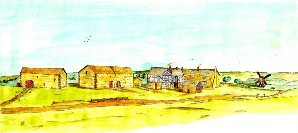
(Fig 1 A reconstruction of the centre of the village of Norton Lees, about 1620-1650.)
Back croft / Smithy croft
The exact location of Back croft is not known, but from the locations given in the maps, it appears to be a cottage on the grounds of Thorpe House. William Thorp is named as the tenant in the fields lists from 1804-05 and 1817 and also from 1845, by which time it was called Smity croft. In 1850 the tenant was Miss Thorpe. Miss Thorpe is usually identified as Charlotte Thorpe, who also lived in nearby Thorpe House.
Two cruck barns once stood in the grounds of West View. The larger of the barns measured 24.8 m long by 6.4 m wide. The smaller barn measured 18.5 m by 5.0 m. These barns survived well into the 20th century. The larger one had been demolished by the time of the 1935 OS map and the smaller survived for some time after that, but was not on the 1956 map. These barns give us a rare insight into the vanished early part of the village. Cruck buildings dwindled in popularity by the sixteenth century due to a change in fashion to post and truss construction, but also possibly because of a rising demand in curved oak timbers for ship building. They certainly would have been earlier than Bishops’ House.
Lamb croft
To the SW of Lees House is an isolated farm. It, or the field next to it are named as Lamb Croft or Upper Lamb Croft. In 1804-05 and also 1817, the tenant is named as Joseph Garfit. He was a file smith. He married Mary Shaw in 1801. They had ten children: John Garfit (b 1801), Charles Garfit (1803-1827), Mary Garfit (b 1805), Hannah Garfit (1808-1823), Job Garfit (b 1810), Thomas Garfit (b 1812), Sarah Garfit (b 1814), Eliza Garfit (b 1816), Gervas Garfit (b 1820) and Harriet Garfit (b 1822). By the time of the 1841 and 1851 censuses the tenant was Richard Gillatt, farmer (1796-1868). He and his wife Mary Ann Gillatt (b 1803 or 1806) had eight children: John Gillatt (b 1824 or 1826), Richard Gillatt (b 1825), Mary Gillatt (b 1829), Thomas Gillattt (b 1832), Susannah Gillatt (b 1834), Joseph Gillatt (1833-1866), Ann Gillatt (b 1837) and William Gillatt (b 1840). The buildings appear on the 1805, 1845, 1875, 1894, 1898 and 1906 OS maps and the 1850 map of the sale of the Shore estate. Unfortunately the Gillatt family moved away and there are no later maps with which to trace the occupiers.
Norton Lees Cottage/The cottage
The building can be traced to 1849. In the sale of the Shore estate, it is described as ‘carriage-house, stables, gardens, and farm buildings.’ It may well be older but it has not been possible to trace the occupants with certainty. In the 1891 census the occupants are Ellen Thornton, a widow (b 1844), her sister Elizabeth A Roberts (b 1842), and boarder and servant. By 1901 George H Beverley, butcher and farmer (b 1848) and his wife Emily Beverley (b 1848) were living there with their servants. He has given his name to Beverley’s Road, which runs alongside part of the cottage, now called ‘Cottage Farm’ with ‘The Barn’ next to it, going uphill.
Silvester Croft
Silvester croft lies to the south east of The Hollies. A Silvester (or sometimes spelled Sylvester or Selvester) family are recorded as living in Norton Lees, among the Norton Parish records in the 17th and 18th century and we assume that they gave the building its name.
Four burials of the Sylvester or Selvester family of Norton Lees were recorded from 1675 to 1680. There is no record of their ages but the close spacing in time of four people probably means that they were all children: Margaret Sylvester (bur 1675), William Selvester (bur 1677), John Selvester (bur 1679) and Elizabeth Selvester (bur 1680). Sara Sylvester, widow, was buried in 1715. Was she their mother?
The next record is of Nicholas Sylvester and Alice Silvester who had five children: John Sylvester (b 1713), Samuel Sylvester (b 1716), Ruth Sylvester (b 1721), Alice Sylvester (1724-1728) and Sara Sylvester (b 1727). Alicia Sylvester, spouse of Nicholas Sylvester was buried in 1754. Nicholas Sylvester was buried in 1756. Their eldest son, John became a ‘naylor.’ He married Julyana (or Julina, or Juliana or Julianah) Ragg of Sutton in 1738. The couple had eight children: John Sylvester (b 1740), Ruth Sylvester (b 1742), Julyana Sylvester (b 1745), Sarah Sylvester (1746-1748), Joseph Sylvester (b 1749), Alice Sylvester (b 1752), Hannah Sylvester (b 1755) and Edward Sylvester 9b 1758). Their second son, Samuel, also a naylor, married Elizabeth Sylvester. They had six children: Alice (b 1739), Samuel (1743), Mary (1745), Esther Sylvester (1747-1749), Moses Sylvester (b 1750) and Titus Sylvester (b 1753).
Elizabeth Sylvester, spouse of Samuel Sylvester was buried in 1739. The cause of death is listed as ‘childbed.’ This date is coincidental with the birth of Alice, so it seems that she died in childbirth. The marriage of Samuel Sylvester and Elizabeth Chantney is recorded in 1741 (NPR v2 p354) so it is likely that the four later children are from this marriage.
There is then a gap of some fifty years before Silvester Croft is mentioned by name in the list of fields from the 1804/05 map. The tenant was ‘Anderton,’ and by 1817 it was John Gray. Ellen Brittain is shown occupying the property in 1845 and 1849. The 1841 census shows Helen Brittain, undoubtedly the same person, living at The Hollies. She was 50 in 1841, so born in 1791. The earliest of the large scale OS maps, from 1875 does not show the property, and we must assume that it had been demolished by that time.
St Paul’s, Norton Lees
William Cockayne gave an acre of land for the new church and vicarage. The foundation stone was laid on Monday the 25th of October 1875 by Mr and Mrs Cockayne. The church was to be built in Early English style with sufficient accommodation for 300 worshipers and allowing for a later extension if required. The architect was Mr T D Webster of Sheffield. The mason was Mr T Rodley. Mr T Badger was the joiner. Messers Harrison and Chadwick were the plasterers and slaters, Mr Corrie was the plumber and Mr Hopworth was the painter. The estimated cost was $4,000. $1,000 was raised by subscription and the rest was donated by Mr Cockayne. The church was built in Dunford Bridge Stone and was roofed with varied coloured tiles. The stones at the apex of the gable had richly foliated crosses. The stone carving was done by Mr Hems of Exeter. The interior of the church was just over 100 ft from east to west. The nave was 73 ft by 25 ft. A vestry which served as an organ chamber was built onto the south side of the chancel and the bell turret below the spire at the north west of the building was octagonal. The organ was built by Conacher of Huddersfield and cost $300. The vicarage was built in 1899, twelve years after the church. St Paul’s Church was altered in 1935 by adding broad north and south aisles and was redeveloped in 2006-07.
Fig 5 St Paul’s church.
Thorpe House
Our earliest certain reference for Thorpe House comes from 1656, though it may have been there in 1640. It was occupied by William Thorpe (b 1617), the son of Owen Thorpe. William married Kathrin Stinfelay in 1658. They had twins, Thomas and Mary, also born in 1658. The will of William Blythe III, of Bishops’ House, from 1665, mentions Thorp House. Though there are gaps in the record, several generations of the Thorpe family lived in the house over two centuries. Our next record is of Godfrey Thorp and his wife Maria Thorp and their two children: Maria Thorpe (b 1716) and Godfrey Thorpe (b 1718). Godfrey Thorpe was buried in 1751. A possible next generation is John Thorpe and his wife Hannah Thorpe, who had four children: Maria Thorpe (b 1733), Robert Thorpe (b 1734), John Thorpe (b 1739) and another John Thorpe (1749-1749). The 1798 Norton tax return lists William Thorpe. Another William Thorpe (1747-1822) married Sarah Thorpe (1746-1823) before 1777. They had seven children: William Thorp (1777-1833), Martha Thorp (b 1780), Samuel Thorp (1782-1809), Hannah Thorp (b 1784), Thomas Thorp (b 1785), George Thorp (b 1789) and Charlotte Thorp (b 1792).
The House was rebuilt in 1829. The 1841 census records Charlotte Thorpe (b 1792) living there with her son William (b 1829). She lived there until the house was sold, following the collapse of the Parker, Shore bank, when much of the local land and property was sold. William Cockayne, a draper, bought Thorpe House for $4,000 in 1850. He was the founder, with his brother Thomas Bagshawe Cockayne, (1802-1871) of the large department store on Angel Street (T.B. and W. Cockayne, later Schofields). The Cockayne family lived there until the 1880s. William Cockayne (1806-1884) married Mary Shepherd (1814-1877) in 1832 and lived in Thorpe House with their children: William Cockayne (1833-1898), Edward Shepherd Cockayne (1836-1889), Walter Thomas Shepherd Cockayne (1841-1901), John Cockayne (b 1843), Anna Maria Cockayne (1844-1915), Bagshaw Cockayne (1845-1892), Mary Agnes Cockayne (b 1849) and Leonard Cockayne (1855-1934). Leonard emigrated to New Zealand and became that country’s greatest botanist. In 1829 William Cockayne (1806-1884) and his brother Thomas Bagshawe Cockayne (1802-1871) opened a draper’s shop at 1 Angel Street. The company was incorporated in 1899 by which time it had expanded into a large department store with its own cabinet making factory. This store was destroyed together with many of the company’s records in the Sheffield Blitz of December 1940. The company continued to trade, utilizing various premises in the centre of Sheffield, and were able to reopen the first phase of the new store on the old site in 1949. The final phase of rebuilding was completed in 1955. In 1972 T.B. and W. Cockaynes Ltd was taken over by Schofields (Leeds) Ltd and the name of the store changed to Schofields. The store closed in November 1982.
By the time of the 1891 census, George Hall (1839-1907), an engineer’s tool manufacturer was living there with his wife Clara Hall (1858-1932). George was apprenticed to Brookes Brothers and soon progressed to manufacturing and factoring hand tools. He was joined by his brother Joseph in 1878 and the partnership was formalised from 1885. George rose in fame to be appointed Master Cutler in 1904. The Trade Directories list George Hall living there from 1901 until 1907 when he died. From 1910 until 1931 the occupant is listed as Mrs George Hall (Clara Hall). She died in 1932 after which the contents of the house were auctioned off, in May 1932. At some time between then and 1934, the house was demolished for the Hollythorpe estate.
Thorpe House Lodge / Thorpe Lodge
Thorpe House Lodge, also known as Thorpe Lodge or simply The Lodge does not appear on any of the early maps. It first appears on the 1875 OS map, so must be a late addition to the village. It appears on the 1894 map and is also on the 1898, 1904 and 1923 maps, where it is labelled ‘Lodge.’ It has gone from the 1935 OS map, along with almost all the original buildings of the village. In the 1891 census Charles N Hobson, coachman (b 1859) was living there with his wife Sarah Hobson (b 1859). They had three children: Nellie Hobson (b 1887), John W Hobson (b 1888) and Leonard Hobson (b 1891). By the time of the 1901 census the occupants were Charles Atkinson, coachman 9b 1857) and his wife Eliza Atkinson (b 1853).
The Vicarage
The vicarage for St Paul’s Church was built in 1889, costing $1,250. The first occupants, from the 1891 census, were the Rev. William Mercer (b 1845) and his sister Jane Mercer (b 1843) and their servants. By 1901 the Rev. Vaniah Odom (b 1848) and his wife, Mary Anne Emily Odom (b 1853) were living there with their children: Emily Violet Odom (b 1889), John Henry Odom (1892) and their servants.
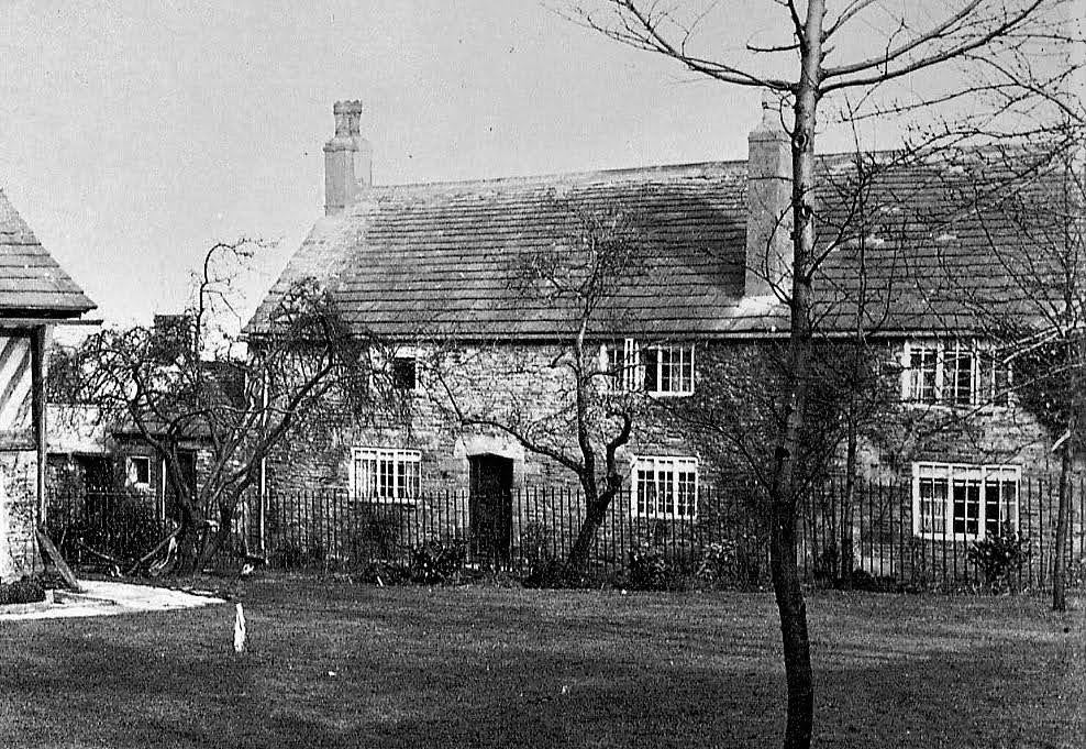
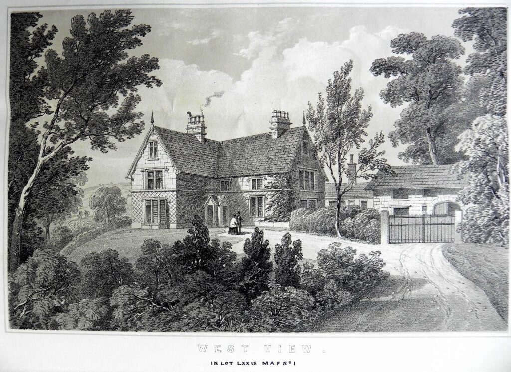
West View was a substantial building in the village of Norton Lees, built before 1804/05. The earliest recorded tenant was John Gray in 1804/05 and 1817. The record from 1850 describes a ‘Mansion House comprising Dining, Drawing and seven Lodging Rooms, with Kitchen, and Cellar, with Stables, Carriage House, Outbuildings, Yard, Garden, and Pleasure Ground’ with a widow, Mrs Sarah Parker (b 1812) living there with her servants up to at least 1871. The 1881 and 1891 census returns show that it was occupied by William Marmaduke Dixwell Alderson (1836-1877), his wife Josephine Rachael Alderson (nee Spear) and their children: Josephine Isabella Alderson (1858-1949), Ethel Westbina Alderson (1861-1880), Lilian Augusta Alderson (1863-1942), Marmaduke Jonathan George Alderson (1864-1925), Jonathon Alderson (1865-), Blanche Violet Maria Alderson (1866-1945), Gertrude Adeline Maud Alderson (1868-1940), Augustus Dixwell Alderson (1869-1944), Percival Charles Newsam Alderson (1870-1959), Mabel Evelyn Alderson (1873-1955) and George William Rowland Parker Alderson (1877-1902) and their servants. The property came up for auction in June 1927. West House was let as flats after the war, the last occupants moving out by 1967. The house was demolished and the current block of flats on the site were built about 1970.
The windmill
There is considerable evidence that a windmill once stood at the eastern end of the village of Norton Lees, to the east of Bishops’ House. No trace of it remains today, and it doesn’t appear on any of the old maps, yet there is both documentary and physical evidence that it was once there.
To the east of Bishops’ house, field no. 755 is called Upper Windmill field, field 754 is called Middle Windmill field and field 753 is called Lower Windmill field on the Fairbank map of 1804-05. By the time of Bright’s 1845 map, the field boundaries had changed but the westernmost of these fields (755 on the 1804 map), now numbered 715 is still called Upper Windmill field. Field 714, to its east, is called Lower and Middle Windmill field. The name was lost forever a few years later. The space occupied by field 755 on the 1804/05 map and 715 on the 1845 map became field no. 109, and was called Storth on the 1849 map involving the sale of the Shore estate.
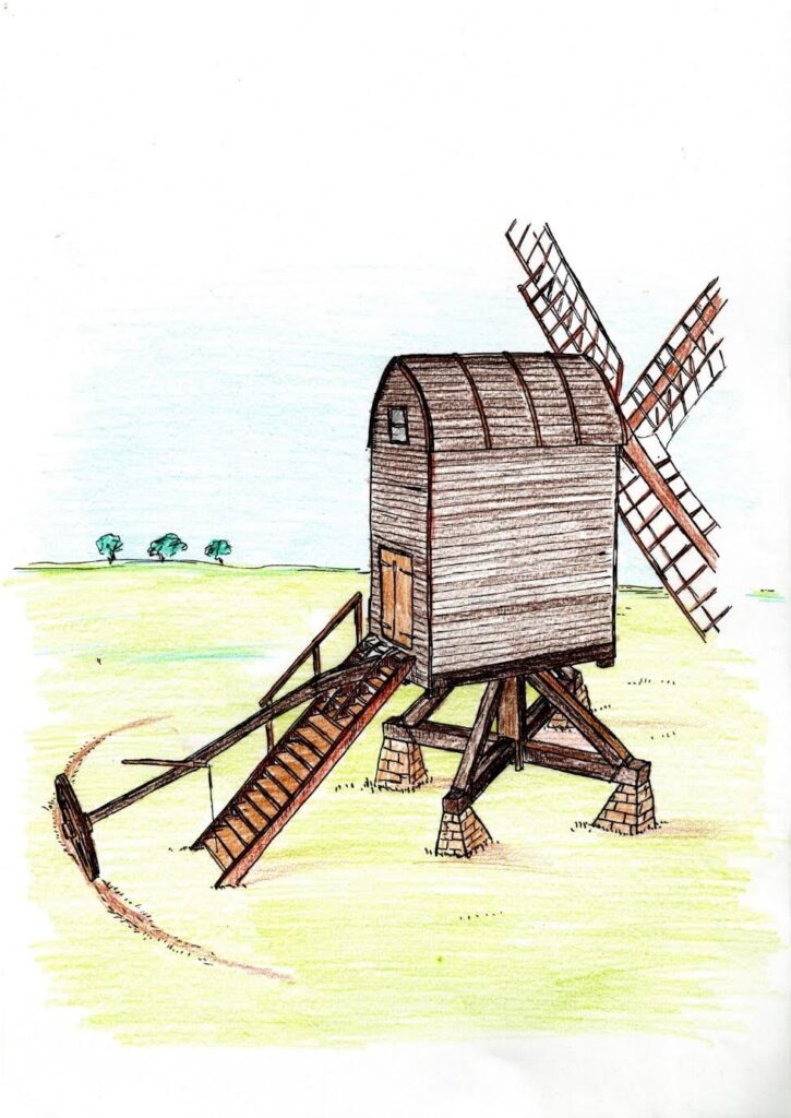

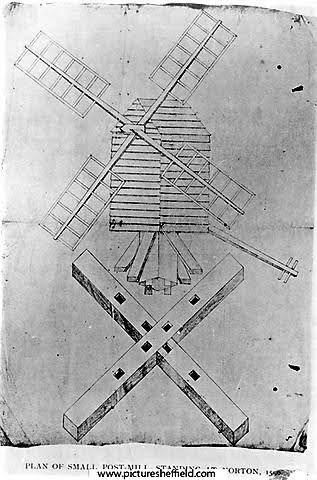
So what is going on?
© 2020 Friends of Bishops’ House. All Rights Reserved.
Friends of Bishops’ House is a UK registered charity, number 1150722, and company ltd by guarantee number 08307595
Privacy Policy / Terms of Use